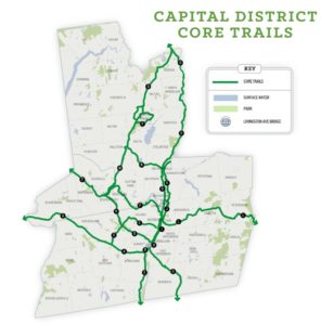
“The CDTC Capital District Trails Plan . . . looked to expand the 89 mile hodgepodge of existing muliti-use trails and bike lanes . . . into a 389 mile network of 18 core trails supplemented by many more miles of supporting segments.”
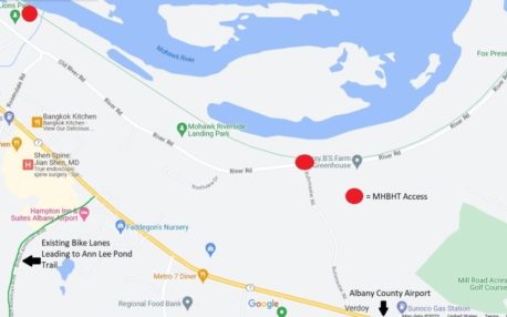
“There are no safe bike/ped passages in Colonie South of Route 7/Troy-Schenectady Road and West of the Northway to the MHBHT even though it is less than a mile to the North.” .
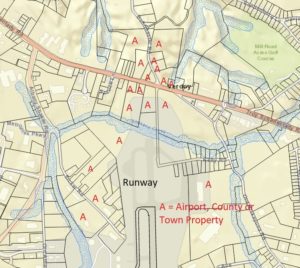
“Unused property outside the Airport’s security fences that are too close to the runways for development have potential for a multi-use trail.”

“The Northern Bike-Ped Airport trail would not just connect people and facilities to the East and West of the Airport, it should also provide a connection to the EST access point at the Northern end of Buhrmaster Road.”
Creating a Capital Region Trail Network
In 2019 the Capital Region Transportation Council (formerly the Capital District Transportation Committee), our regional federally recognized Metropolitan Planning Organization, released its Capital District Trails Plan. That long range plan looked to expand the 89 mile hodgepodge of existing multi-use trails and bike routes in Albany, Rensselaer, Schenectady and Saratoga counties into a 289 mile network of 18 connected core trails supplemented by many more miles of supporting segments. The trail network would provide safe connections between our region’s communities for alternative transportation users.
While we advocate for making all roads accessible for all kinds of users, these separated multi-use trails are extraordinarily popular. Since the Trails Plan came out there have been some notable achievements to the goal of connecting and expanding our trails, including:
- New York State completed the new Albany-Hudson Electric Trail segment of the Empire State Trail (EST) providing a trail connection from Albany all the way to the City of Hudson and beyond.
- New and upgraded segments of the EST in Schenectady and Montgomery Counties have vastly improved non-motorized travel between Schenectady and Amsterdam.
- The Albany City South End Connector joined the Albany County Rail Trail to the Corning Trail segment of the EST.
- The Eastern end of the Zim Smith Trail in Saratoga County was extended to the City of Mechanicville and work is underway to connect the Western/Ballston Spa end of the Zim Smith to Saratoga Spa Park as well.
- The City of Saratoga Springs Greenbelt Trail saw completion of the Geyser Road Trail and efforts are underway to complete its Downtown and Crescent Avenue connectors.
- Improvements to the Champlain Canal Trail segment of the EST have nearly connected Waterford to the Southern end of Mechanicville with a bucolic off-road stone dust trail. (Beaver activity just South of Mechanicville created unexpected environmental, engineering and cost issues that have yet to be resolved.)
The Colonie Trail Gap
One missing trail connection that has been particularly irksome to alternative transportation advocates in Colonie is the lack of a safe connection to the Mohawk Hudson Bike-Hike Trail (MHBHT) segment of the EST from the nearby trail network comprised of the Ann Lee Pond/Shaker Trail and the connecting Bike Lanes along British American Boulevard. In general, there are no safe bike/ped passages in Colonie South of Route 7/Troy-Schenectady Road and West of the Northway to the MHBHT even though it is less than a mile to the North. The brave or foolhardy can get to the MHBHT access point at Lion’s Park from Colonie via the treacherous, busy, narrow and windy Rosendale Road. There is an access point from Buhrmaster Road, but there is no signalized crossing at the intersection of Troy-Schenectady Road and Buhrmaster.
For quite some time advocates have tried to convince the Town of Colonie to provide a safe connection to the MHBHT from the signalized intersection of British American Blvd where the bike lanes connecting back to the Ann Lee Pond trails currently terminate. Letters and attendance and numerous planning board meetings relating to business projects on the North side of this intersection have amounted to naught. There is a road project planned for the Rosendale Road/River Road intersection by the MHBHT access point at Lion’s Park. However, despite advocacy efforts, the project will not include improvements needed along Rosendale Road.
Opportunity to use vacant airport land
The Albany Bicycle Coalition and other advocates have recently shifted their focus to vacant properties of the Albany County Airport to provide safe transportation routes for alternative transportation users. Unused property outside the Airport’s security fences that are too close to the runways for development have potential for a multi-use trail. This was done around Baltimore-Washington International Airport. Since the Airport is in the process of updating its Master Plan, this is an ideal time to take a serious look at this opportunity.
The Airport Master Plan should include a bike-pedestrian path to both improve transportation options across airport properties and to rectify mobility issues created by the airport and its expansion. It is important to note the airport eliminated thru roads such as Sicker Road and have helped concentrate more motor vehicle traffic on roads such as Route 7/Troy-Schenectady Road to the North and Albany-Shaker Road to the West and South. This has created excessively long and dangerous routes for pedestrians and cyclists.
There have been efforts to create sidepaths and safe crossings along Albany-Shaker Road and there are now connections to the Ann Lee/Shaker Bike Path System to the West. Creating a multi-use path on vacant airport property on the Northern side of the airport, outside any security fences, could greatly improve bicycle and pedestrian transportation across that area.
Ultimately, the Northern Bike-Ped Airport trail would not just connect people and facilities to the East and West of the Airport, it should also provide a connection to the EST access point at the Northern end of Buhrmaster Road. The State of New York has invested millions of dollars in creating the EST. It is drawing tourists from all over the world and Albany County is at the crossroads of its North-South and East-West trails. It is sadly ironic that people can enjoy 750 miles of hiking and biking on this trail that is under a mile from the Airport – but hikers and cyclists arriving at the Airport are told they need to hire a cab to get there, because there is currently no safe, simple way to get from the Airport to the EST.